GEFIS Gewerbeflächen-Informationssystem
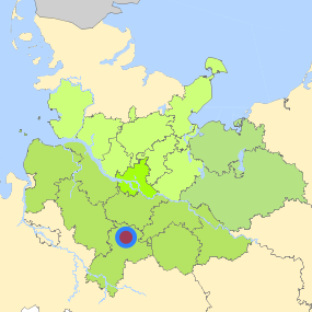
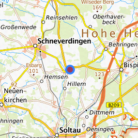
Gewerbegebiet Heber (018) at Schneverdingen, Heidekreis
Legend
Availabilities
Immediately
short term (2 years)
medium term (2-5 years)
long-term (> 5 years)
optional area (bindingly reserved)
occupational pension plan
not available
Brief description
Description of the parcel
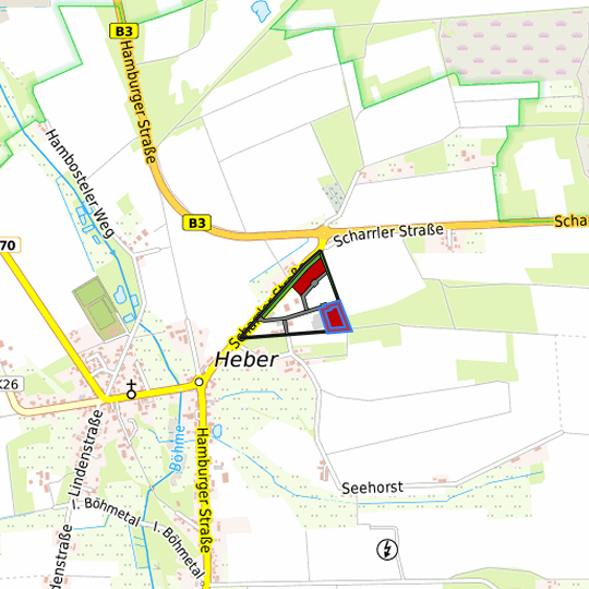
Gewerbegebiet Heber
Municapility/city
Schneverdingen
Parcel
Property size (m²)
7,932.55
Availability
immediately available
focus use
other usage
further use
unavailable
Legal planning situation
Commercial space secured by planning permission
Yes
Building area according to land use plan
commercial building area
Existing planning law
§30 BauGB (qualified development plan)
Type and extent of building and land use
Specific type of structural use
GE
Development situation
fully accessible
24-hour operation
Not specified
possible site occupancy ratio
8
possible floor area figure
16
possible number of full floors
No information
possible height of building structures
No information
cubic index
No information
Exclusions/restrictions of land use
restrictions to mobilization
Not specified
Infrastructur of site
broadband availability (at least 50 MBit/s)
Yes
quay edge
Not specified
quay edge with sea-going vessel deep water
Not specified
direct rail connection
No
electricity connection
Yes
gas connection
Yes
water connection
Yes
wastewater connection
Yes
Proprietary situation and marketing intention
proprietary situation
Not specified
Detailed information about commercial zone
Gross surface area (ha)
8.0217
Sector focus
construction industry
other manufacturing sectors
trade, maintenance and repair of motor vehicles
Type of location of commercial estate
location for crafts and small-scale trades
classic commercial estate
Transport accessibility
Motorway
A 7
6.7
km
Motorway
A 1
33.8
km
Motorway
A 27
37.7
km
Motorway
A 261
41.0
km
Motorway
A 39
41.2
km
Motorway
A 253
47.8
km
Motorway
A 26
53.6
km
Main road
B 3
0.2
km
Main road
B 71
11.4
km
Main road
B 209
12.0
km
International airport
Flughafen Hamburg
70.6
km
International airport
Flughafen Hannover
77.9
km
International airport
Flughafen Bremen
82.0
km
Regional airport
Flughafen Lübeck
115.6
km
Regional airport
Cuxhaven
130.7
km
Commercial airfield
Rotenburg (Wümme)
40.7
km
Commercial airfield
Hodenhagen
44.1
km
Commercial airfield
Uelzen
51.5
km
Commercial airfield
Weser-Wümme
52.5
km
Commercial airfield
Uetersen/Heist
84.6
km
Port
Binnenhafen Lüneburg
49.2
km
Port
Seehafen FHH
53.9
km
Port
Binnenhafen Geesthacht
60.6
km
Port
Binnenhafen Uelzen
61.7
km
Port
Binnenhafen Lauenburg
65.0
km
Rail freight traffic
Emons Spedition GmbH
59.2
km
Intermodal terminal
Soltau Logistics-Center
14.8
km
Intermodal terminal
Hafen Lüneburg (trimodal)
49.2
km
Intermodal terminal
Holborn Raffinerie (FHH, trimodal)
50.3
km
Rail passenger transport
Schneverdingen
6.7
km
Rail passenger transport
Wolterdingen(Han)
7.1
km
Rail passenger transport
Soltau Nord
11.6
km
Rail passenger transport
Soltau
12.0
km
Rail passenger transport
Wintermoor
12.4
km
Public transport
Heber(Schneverdingen) Scharrler Stra
0.1
km
Public transport
Heber(Schneverdingen) Seehorst
0.4
km
Public transport
Heber(Schneverdingen) Kirche
1.0
km
Availability of public transport
Not available
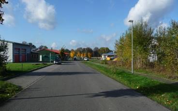
Photographs of the commercial zone

Information about Schneverdingen
Inhabitants of the municipality
19,400
Trade tax rate
380
Property tax B
380
Photographs of the location

Links to the location
Contact
Anja SchwarzWohnungsbau-, Ansiedlungs- und Fremdenverkehrsgesellschaft Schneverdingen mbH
Grundstücksverwaltung
Schulstraße 3
29640 Schneverdingen
Contact
Anja SchwarzWohnungsbau-, Ansiedlungs- und Fremdenverkehrsgesellschaft Schneverdingen mbH
Grundstücksverwaltung
Schulstraße 3
29640 Schneverdingen